To enter the public transport system, people need to travel from their location to a public transport node such as a bus stop, train station, ferry terminal or airport. Depending on the distance to the public transport node, public transport options and the local setting, people may do this by walking, travelling in a mobility device (such as a wheelchair or motorised scooter), catching a taxi or ride share, driving a private vehicle and parking at the station, or being dropped off by another person.People with disability have highlighted that the start and end of their journey can often be problematic due to a lack of information about the environment they are entering. This is also a challenging part of the journey for transport operators and service providers because they often have no control over conditions surrounding the public transport infrastructure.
The journey start and end is managed and affected by a range of stakeholders including local government, state and territory government departments, private developers and landowners, and utility providers (such as telecommunications, gas or water). When issues arise during this part of the journey it can be difficult for public transport users to work out which organisation to contact for assistance.
This part of the journey is not addressed by the Transport Standards, but is subject to broader DDA requirements.
Aspirations for this journey part
- Travelling to and from public transport nodes is easy and efficient for people with accessibility requirements.
- Stakeholders involved in managing the environment surrounding the public transport network understand the impact their actions have on public transport users, and work cooperatively to resolve issues and explore opportunities.
Excerpt from submission to the 2012 Transport Standard review—John McPherson
“Unless the pedestrian and transport connections between transport nodes are fully accessible, transport nodes risk being no more than accessible islands in an inaccessible ocean. Large areas of both urban and rural landscape currently feature these archipelagos of accessibility, with their scattered stops, stations and terminals embedded in a matrix of difficult access paths and poorly coordinated multimodal transport routes.”
How can we achieve this?
3.2.1 Transparent information about accessing stops/stations/terminals
Having a stop, station or terminal that complies with Transport Standards does not automatically make the infrastructure accessible. Issues such as topography in the vicinity of transport infrastructure and legacy streetscape features are not easily resolved.
Therefore, information needs to be made available about the environment surrounding public transport infrastructure. This would enable people to plan their journey based on their individual needs and be directed to use suitable routes to public transport nodes. This is especially relevant to footpath gradients, quality and continuity, and the availability and suitability of kerb ramps.
3.2.2 Pathway quality
Pathways leading to public transport nodes should be maintained to a high standard by the relevant authority. This will make this part of the journey as safe, convenient and comfortable as possible for those with accessibility requirements. Improving pathways means fixing broken pavements, maintaining levels, managing street clutter and avoiding trip hazards.
The Western Australian Department of Transport has collaborated with a number of state government authorities, local bodies and organisations to develop the comprehensive Planning and Designing for Pedestrians: Guidelines publication. This encompasses disability standards. It was rolled out to local government with a series of workshops in 2012 and was reviewed in 201625.
When designing journeys, approaches and pathways, it is desirable to take into account the relationship between pedestrian movement patterns and the path of the sun (daily and annual) to maximise shade during the day when most people use the route26.
In regional and rural areas, not all footpaths will be paved or sealed. Areas in the vicinity of public transport infrastructure should be prioritised for this treatment. Where this is not possible, measures should be considered such as compacting the existing soil to create a smooth surface, rather than using materials that could be uneven or unstable, such as gravel. In some instances, an alternative stop location could be considered that might achieve a better result.
3.2.3 Obstructions
People with disability have highlighted significant issues that impact access to public transport. These include temporary signage (such as A-frames), parked cars, retractable barriers, low hanging branches, commercial activity such as café or retail display stands, construction works and other obstructions along pedestrian pathways. The Australian Human Rights Commission has provided guidance on footpath and access requirements27 as part of the Disability Discrimination Act 1992.
Increasing awareness of these issues within the community will improve access to the public transport system.
Where required, those with enforcement powers such as local government, should work with stakeholders to maintain unobstructed paths, especially in the vicinity of public transport infrastructure.
For example, to ensure effective collaboration between stakeholders, the Yarra and Melbourne councils in Victoria have helped develop footpath use policies28.
3.2.4 Precinct planning and coordination
Stations often function as the centre of many communities, and are important nodes in a neighbourhood. A series of activities at stations can transform a station or stop into a multi-use destination.
Where public transport nodes sit within a precinct—such as a retail, health, education or sporting facility or airport terminal—planners and managers should consider how activities within the precinct impact access to public transport, especially for those with accessibility requirements.
From a planning perspective, precincts should be designed with their role as a conduit and supporter of public transport infrastructure in mind. This may involve integrating seating, clear wayfinding information and cues, shade and other supporting infrastructure into the area. An example of the effective delivery of a precinct plan is the extensive network of signage established by the City of Sydney and Brisbane City Council for people who are blind or who have low vision. These networks use Braille and tactile street signs on the mast of traffic signals that feature audio tactile pedestrian crossing controls29.
From a management perspective, the area's role in public transport journeys should be acknowledged and respected through day-to-day precinct management. Actions that take place in the precinct have the potential to impact people's public transport journeys.
An example is the Australian Taxi Industry Association, which has sought to address this need through its Taxi Rank Design Specification30. This guides the process of designing accessible taxi ranks for various facility types located in urban centres.
Taxi Rank Master Plans31 have been developed for Adelaide, Brisbane, Canberra, Melbourne and Sydney.
3.2.5 Temporary works
Pedestrian movement and informal desire lines should be considered when there are temporary works in the vicinity of public transport infrastructure that impact pathways, kerb ramps and pedestrian crossings. For example, organisations that approve works and management plans should require that provisions such as temporary kerb ramps be included where no other safe, convenient and accessible options exist.
People who are blind or who have low vision say that they struggle with these types of temporary works as signage is often used to direct people to detours. Alternative ways to communicate changes and detours, or a combination of measures, should also be considered, for example temporary fencing in place of bollards.
Consideration should also be given to how temporary changes and diversions are communicated so people can be informed about changes that may affect their journey.
Utility owners should consider the impact of their work on accessibility, especially in relation to temporary works and reinstating pavements, particularly in the vicinity of public transport infrastructure.
| Clarifying responsibilities Western Australia's Public Transport Authority has worked closely with local government to clarify roles and responsibilities for planning and designing public transport infrastructure. The authority sought legal clarification to ensure that it understood its responsibilities and that staff were better informed where planning, maintenance, and upgrades were required to the network. This also gave local government confidence in what its scope entailed, and enabled more open dialogue where funding was required to support accessible upgrades. |
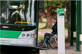
 Figure 4—Blue Cat Bus in Perth |
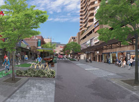
| Complete streets approach for designing safe access for all users The complete streets approach recognises that streets are destinations, and that good design ensures people who travel as pedestrians, cyclists or on public transport have just as much right to use the streets as drivers. Outcomes of this approach have resulted in streets that are more pedestrian friendly, have improved safety and security through good design and surveillance, provide more permeable and legible street networks, and improve bus operations through appropriate allocation of street space. |
 Figure 5: Bondi Junction Complete Streets Project32 © Waverly Council, NSW |
| Cities unlocked A pilot project undertaken in the UK between Future Cities Catapult, Guide Dogs and Microsoft, is improving mobility and navigation for people with low and no vision. The project was piloted in London. It uses a headset and smartphone app that provides the wearer with a 3D soundscape for a richer understanding of their surroundings. |
 Figure 6 – Cities Unlocked33 |
25 Western Australian Local Government Association submission on the draft Guide.
26 Royal Australian Institute of Architect submission on the draft guide with references to Kennedy (2010), Subtropical Design in South East Queensland: A handbook for Planners, Developers and Decision Makers, QUTe-prints, p.29.
27www.humanrights.gov.au/our-work/disability-rights/publications/advisory-note-streetscape-public-outdoor-areas-fixtures
28www.yarracity.vic.gov.au/services/business-in-yarra/business-permits-and-regulations/footpath-trading
29 John McPherson submission on the draft guide.
30www.atia.com.au/wp-content/uploads/Generic-Taxi-Rank-design-specification.pdf
31www.atia.com.au/publications/taxi-rank-master-plans/
32www.waverley.nsw.gov.au/building/current_projects/bondi_junction_projects/great_places/complete_streets